October 14th
2015
Cicerone
Guide: The Yorkshire Dales, North and East, Walk 22
Map: OL 30
Sometimes
there are walks that just have to be done, despite the fact that dogs cannot go
with you. Today was one such walk. It took in part of the Pennine Way, but then
veered off across open access land – where even dogs on a lead are not allowed,
because there are no public rights of way. It is not a rule I understand,
because if people can go tramping around, why can a dog on a lead not accompany
you? Anyway, I like to keep to the rules, so today’s walk was minus Storm. As it turned out, that was probably
just as well. The guide book said the walk should take 3½ hours; I thought that
was probably over optimistic and estimated I should be back at the car between
5.30pm and 6pm.
I parked
just above a little village called Thwaite, between Muker and Keld, at about
1.30pm. Normally, we walk from either Muker or Keld and never see Thwaite
because those walks are in the valley next to the river and Thwaite is the
other side of the hill. But it is a village worth a visit, with plenty of walks
around it – and it has a pleasant tea room if you want to start or finish a
walk there.


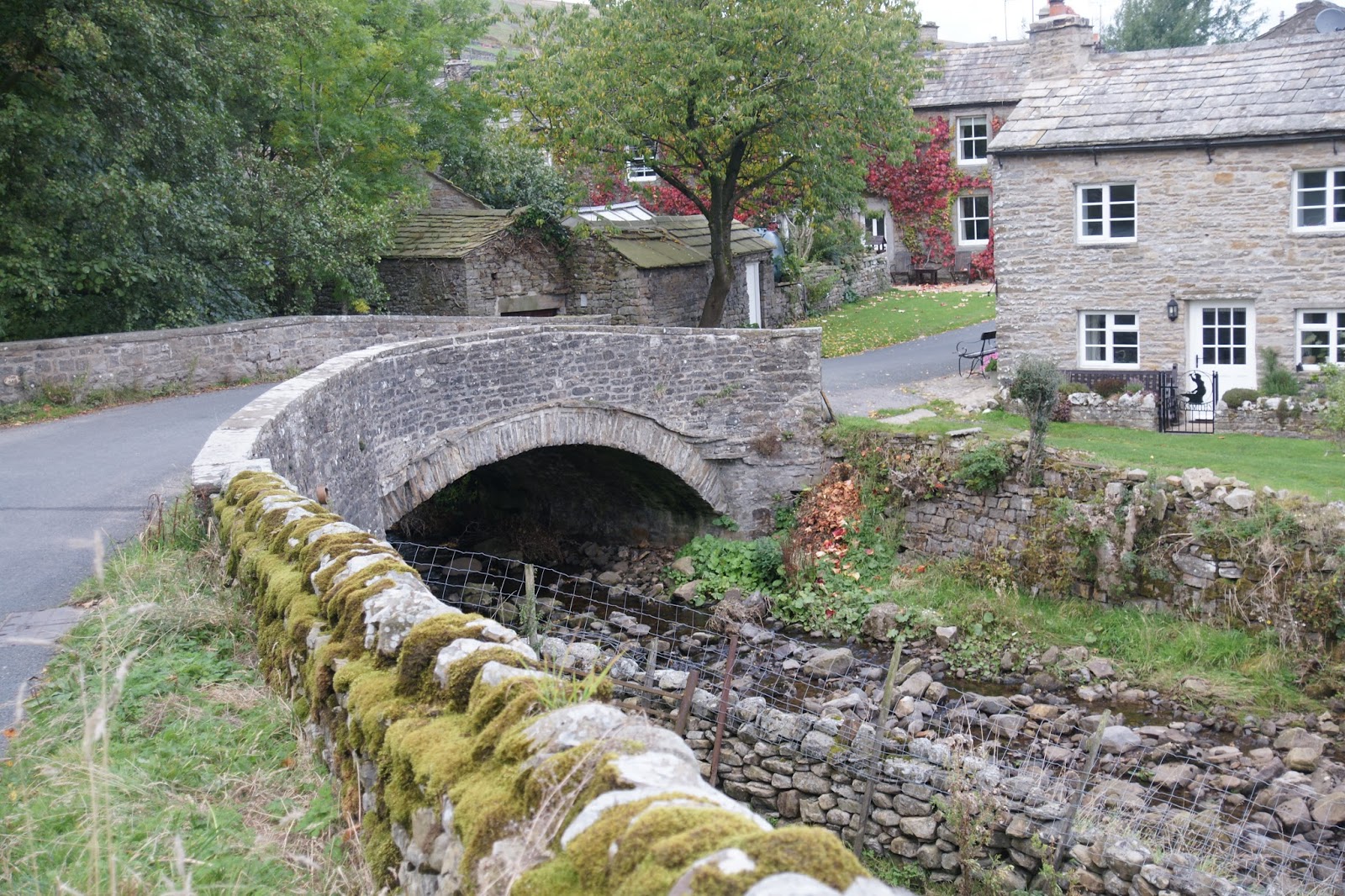
The car park
is a small layby just to the Thwaite side of a road left that crosses
buttertubs pass into Hawes in Wensleydale. I headed into the village, crossing
a lovely old stone bridge, before coming to a small cluster of houses.


Many of them seem to be holiday lets and I wondered how many were still lived in all year – a common occurrence in the Dales these days. It only took me around five minutes to walk completely through the village, then, as the road started to climb, I took a footpath to the left.

There was a signpost at the gate, telling me that Great Shunner Fell was 3½ miles away.


Passing
through the gate, I followed a small stream, Thwaite Beck. There were a couple
of lovely waterfalls – not large ones, but pretty enough that I left the track
momentarily to photograph one.

Entering the
third field from the road, the path turned steeply to the right A random post with a waymarker on it, points the direction:

Then crossing another very small enclosure (containing two sheep), I passed through another gate and onto a track. The guide book simply called it a track, but it was in fact part of the Pennine way. I didn’t realise this at first, but the state of the ground underfoot in places, led me to think it might be and when I had the opportunity to look closely at the map, I found it was indeed the Pennine Way.

Fortunately, some enthusiastic volunteers have laid heavy stones to form a paved path in many places where passing would be impossible otherwise. The problem is, the track gets wet after many feet have crossed it, compacting the ground, so walkers then make an ever widening detour around the wet bit. Paving it is a good solution, but even then, the stones sink eventually into the soft peaty earth beneath.
This ‘track’ would take me all the way to the summit of Great Shunner Fell. It was a fairly gentle climb, but it was definitely ‘up’ all the way – the whole 3½ miles. Anyone who knows me will know that I don’t enjoy ‘up’ very much and I am very slow, so it took me two hours to reach the summit.

Then crossing another very small enclosure (containing two sheep), I passed through another gate and onto a track. The guide book simply called it a track, but it was in fact part of the Pennine way. I didn’t realise this at first, but the state of the ground underfoot in places, led me to think it might be and when I had the opportunity to look closely at the map, I found it was indeed the Pennine Way.

That hill to the top left of the photo is where I am headed.
Fortunately, some enthusiastic volunteers have laid heavy stones to form a paved path in many places where passing would be impossible otherwise. The problem is, the track gets wet after many feet have crossed it, compacting the ground, so walkers then make an ever widening detour around the wet bit. Paving it is a good solution, but even then, the stones sink eventually into the soft peaty earth beneath.
This ‘track’ would take me all the way to the summit of Great Shunner Fell. It was a fairly gentle climb, but it was definitely ‘up’ all the way – the whole 3½ miles. Anyone who knows me will know that I don’t enjoy ‘up’ very much and I am very slow, so it took me two hours to reach the summit.
The views
were spectacular. The higher I got, the more of Swaledale opened out behind me,
until I was high enough to see Muker, then the dips where Reeth and Richmond
lay, hidden by hills, and then, way beyond those, a faint line of hills on the
horizon, which I presume were the Cleveland Hills.

Looking down the valley, where I had come from. You can make out Thwaite and Muker, then hills in the distance, hiding Reeth and Richmond. I think the picture may be too small to see the Cleveland hills properly, but you can just make them out faintly on the original.
The track was well maintained, but petered out when I reached a spoil heap – an ever present reminder of the areas busy and dirty – not to mention dangerous – mining past.

The guide
book assured me the path was paved all the way to the summit from here – except
when it wasn’t!


I reached a
dry stone tower. I had seen this on the horizon for some time and had assumed it
was the summit, but it turned out not to be.


However, the views from here were probably the best on the walk. Looking back and slightly to the west, I could see a large lake. According to the guide book, this is Birkdale Tarn (confirmed by the map), and is the third largest lake in the Dales. However, it is not entirely natural, having been extended to supply water to the workers in the areas lead mines.


The path stretches out uphill, leading to a small cairn on the summit. You can just make it out where the hill behind comes down to meet the top of the footpath.

However, the views from here were probably the best on the walk. Looking back and slightly to the west, I could see a large lake. According to the guide book, this is Birkdale Tarn (confirmed by the map), and is the third largest lake in the Dales. However, it is not entirely natural, having been extended to supply water to the workers in the areas lead mines.

Beyond the
Tarn lay Birkdale Common, Nine Standards Rigg, High Seat and Hugh Seat.
As I was
climbing, a couple of times I passed through a smoky bit and the air was full
of the smell of wood smoke. Farmers are no longer allowed to burn off the
stubble on their wheat fields, but they can still burn off the heather on the
moors as part of land management. Today of course was perfect for doing that –
dry, sunny and pretty still.


The path continues upwards, using what I call a 'trip hazard' method of paving - cobbles, held in place by heavy stones set on edge to hold the cobbles in place. They rise higher than the cobbles, so you have to step over them, making the going very hard.

Obviously, other walkers had decided it was tough going too, and had carved out their own path alongside:

So while the tower was not the summit, this was:

Obviously, other walkers had decided it was tough going too, and had carved out their own path alongside:

So while the tower was not the summit, this was:


It is a dry
stone wall, built in a + shape, allowing shelter to some extent whichever way
the wind might be blowing. The views from the top were fantastic, but to my
mind, not as good as those from slightly lower down the hill.


I stopped
here for a brief rest and to have something to eat. I had eaten a little before
I set off from the lay-by at 1.30pm; it was now 3.45pm and it had been a long
climb. My rucksack was also pulling on my shoulders and making them ache, so
fixing that was also a priority – just as well, when you realise what
transpired after I left this spot! In recent months, I have been losing a bit
of weight and my shape has changed quite a lot. I had not tightened the
waistband to accommodate the thinner me, so the rucksack was hanging off my
shoulders instead of sitting on my hips. Tightening the belt made all the
difference.
The guide
book suggests two courses of action from here – either turn round and return
the way I had just come, or ‘more challenging’, cut out across Little Shunner
Fell and through open access land to reach the Buttertubs raod. Returning seemed
rather dull, so I set off to take the more challenging route. In actual fact, I
did neither of the guide book’s suggestions in the end.
The Pennine
Way stretched out before me like a ribbon, heading south west.

The path was more or less flat at this point and there were some spectacular autumn colours alongside, and a small lake.


About 200 yards from the summit shelter, there was a fence. Beyond the fence was High Abbotside. I found a sign, but it was on the wrong side of the fence:

Keeping to the north side of the fence, I turned left and headed into a pathless terrain.

For the first part, I was to follow the fence, then, where the fence met a wall, I was to follow ‘the way’ to the left, then back to the right. I found the wall and looked for the path to the left. There wasn’t one. For some unknown reason, I failed to take a photograph of this conjunction of wall and fence and in fact, I didn't take any more photos after this, for reasons which will become apparent. Reading the next part of the guide book, it said that the summit of Little Shunner Fell was marked by an insignificant pile of stones, on the other side of the fence. Those words, ‘on the other side of the fence’ were to prove crucial in what happened next. There was clearly no fence heading east, but the fence I had been following did indeed turn left (east) a little beyond the wall and then turned right to head south-ish again. Having read that the summit’s pile of stones was on the other side of the fence, I decided I needed to remain close to the fence.

The path was more or less flat at this point and there were some spectacular autumn colours alongside, and a small lake.


About 200 yards from the summit shelter, there was a fence. Beyond the fence was High Abbotside. I found a sign, but it was on the wrong side of the fence:

Keeping to the north side of the fence, I turned left and headed into a pathless terrain.

Looking south along the fence, I was meant to follow the fence beyond the first dip, then veer off east. What in fact I did, was walk along the whole of the valley you can see below in this photo, nicely lit up in the sunshine at this point!
For the first part, I was to follow the fence, then, where the fence met a wall, I was to follow ‘the way’ to the left, then back to the right. I found the wall and looked for the path to the left. There wasn’t one. For some unknown reason, I failed to take a photograph of this conjunction of wall and fence and in fact, I didn't take any more photos after this, for reasons which will become apparent. Reading the next part of the guide book, it said that the summit of Little Shunner Fell was marked by an insignificant pile of stones, on the other side of the fence. Those words, ‘on the other side of the fence’ were to prove crucial in what happened next. There was clearly no fence heading east, but the fence I had been following did indeed turn left (east) a little beyond the wall and then turned right to head south-ish again. Having read that the summit’s pile of stones was on the other side of the fence, I decided I needed to remain close to the fence.
I followed the
fence down steep banks and through many marshy patches. You know that feeling
you get when you take that one next step – and wish you hadn’t? at that point,
my boots filled with water and my feet were soaked in an instant. The terrain
was really hard going. The guide book had said the land was ‘not as boggy as
you might expect’ – huh! I thought; had the writer actually walked the same
path as me? Any moment, I expected to see a track leading to the road – it never
came into view. Largely, I suspect, because unbeknown to me, I was no longer
following the path in the guide book.
After some
distance (and I mean two or three miles), I realised I was actually heading due
south. I really needed to be going east! I also realised that it was getting
late and that the sun would be setting soon. Every top I crested and every
corner I rounded, I hoped to see some sign of human habitation – a farmhouse,
or a village, anything. There was nothing – except miles of fence stretching
out before me – and all heading south. I had to leave the fence several times
to circumnavigate boggy stretches – in the end, I decided not to bother, as my
feet were already wet, so just walked carefully through them. There were also
some stretches that were difficult to cross – like the top of a small cliff,
which wandered in and out from the banks of the river below; or places where
the fence just disappeared.
A fence
blocked my way across and there was apparently no way through. Upwards was far
too steep; my only course of action was to pass through a gate onto the bank of
the river and follow the river only. The river was still headed south and was
running downhill, so that seemed like a good option, though parts of the river
bank again were hard to navigate.
I decided my
priority now was to get off the fell before it got dark. I had already not taken any photos for some time, as the terrain was so difficult, that photography was the last thing on my mind. I decided that I wouldn't take any more photographs anyway, as they took up time, as I was anxious to get off the fell. I decided I ought to
phone home too, but there was zero signal. Well, I was in a bit of a valley. So
I started to walk diagonally upwards across the fields, to gain height, where I
might find some signal. Two dry stone walls crossed my path, but
providentially, the first had a gateway and the second a broken down bit of
wall, making crossing them easy. Then, as I rounded a curve, I saw in the
distance a couple of twinkling street lights. I have never been so relieved to
see street lights in my life! I assumed (and it turned out to be correct), that
this was probably Hawes. It was still some distance away, but I could walk
towards it, as long as it didn’t get too dark. Walking across open fields is
hard work at the best of times, without attempting to do it in the dark. Many a
rabbit hole has caught a walker unawares and a broken, or sprained ankle was
the last thing I wanted at this stage.
To my left
another wall now appeared, heading the same direction as me. I glanced back at
the river one last time and saw that is was now curving to the west – that was
the last direction I wanted to go. I needed to go east, not west, but south was
fine as the town ahead was to the south and at least I would be able to find
out where I was (I was pretty sure I knew where I was on the map – and it
turned out I was right – but the town was off the bottom of the map and so I had
no way of knowing whether it was indeed Hawes or not) and make my way back to
my car. I decided I could use the wall as a guide if the light failed, as it
was going south. I noticed that the wall had a fence on top of it – that usually
signalled a boundary and there was the likelihood of a track or at least a path
that had been driven on by tractors. There was also a gap in the wall about 100
feet away – and straight up the hill. Looking round, over my left shoulder, I could
see a small house, with a double garage about 500 yards to the north. Garages! That
meant is was indeed a track! I made my way up the field and through the gap in
the wall – and finally stood on a hard, gravelled surface. I determined I would
now follow this track no matter where it led, then, as it was getting much
darker now, when I reached the road, I would turn right (even though I knew my
car was to the left) and head into the town, then take a taxi, if I could find
one, back to my car.
Once the sun
dips below the level of the hills, it gets dark very quickly. There were of
course no lights on this track, but I could see enough to know I was still
headed for the town. There was one ‘scary moment’ where the track turned left
and looked like it was going to head up the hillside opposite. I really didn’t
want to do any more ‘up’, but I knew I had to stick to the track like glue. Fortunately,
it turned right again at the top of a small hill and I resumed my journey
towards the town.
I came upon
a farmhouse and thought, as it was now quite dark, I should stop and ask for
help. There was a vehicle in the drive, the lights were on and there was a
child’s bike in the garden, but I couldn’t get an answer when I knocked on the
door – and I knocked several times and as loudly as I could. Disappointed, I returned
to the track and continued my journey. Another house loomed in the darkness. There
were no lights visible from the side I approached and I almost walked on past. But
at the last minute, I saw a light shining on the other side, so I went in the
driveway, passed a vehicle parked there and through a gate into a small
courtyard/paved garden, surrounded by house on two sides and wall on the other
two sides. I couldn’t see a door at first, but then a security light came on
and a door became evident – but it had pot plants on the steps and inside there
were many pot plants too – clearly this was not a door that was used, but I had
no idea where I might find another door, so I knocked anyway. Very quickly a
light came on and a man appeared. He headed for the opposite side of the
hallway and opened – the real front door!! I knocked again on the door I was
standing at and he indicated I should come round the other side of the house. There
was a second gate which in the dark I had not seen before. Now it was all lit
up, because the owner of the house had turned on the outside lights. ‘Can I
help you?’ he asked. I certainly hoped he could!
At first, he
thought my car was in Hawes or somewhere nearer, like Simonstone, and that I
would be driving the 8 miles (!!) over the pass back to Thwaite. When he realised my car was
actually in Thwaite and that I would need to walk over the pass or find a taxi,
he immediately said he would give me a lift. walking, he said, was really not an option in the dark, as the road is quite dangerous and, it was another 8 miles! He invited me in, made me a cup of
tea (decaff of course, as I am allergic to caffeine) and let me use his phone
to call home. There was no answer, so I presumed (correctly) that OH had gone
out and that he wasn’t therefore worried about me.
I got back
to my car at about 8pm. I had arrived at the man’s house (I never did find out
his name) at 7.40pm, so I had been walking on the fell for nearly four hours! As
I shut the car door, the world was very dark outside – there were no street
lights and no passing cars. I glanced up at the night sky and saw millions upon
millions a stars and was very thankful for a positive outcome to the day. I had
walked many more miles than I had intended, but I had not relished the prospect
of a night on the fell, which was what had kept me going and probably was why I
didn’t feel at all tired. Just the 1½ hour drive home now; I finally got home
about 20 minutes before OH did.
So did I learn anything from my little adventure? Well yes, and to aid anyone else setting out for a walk in the Dales in autumn, here's what I learned. It is all too easy to set off on a lovely sunny day, after having had long summer evenings recently behind us, and forget entirely that the nights are longer and the days shorter, not to mention that it can get pretty cold or even foggy quickly on the fells. Thankfully the latter didn't happen, but that was more luck than judgment on my part.
ReplyDeleteSo, what would I have done differently?
1. I would ensure I had a good torch with me, preferably a headtorch, as you need your hands free when scrambling over difficult terrain.
2. Faced with the prospect of a night on the fells (I really wasn't looking forward to that!), I would have made sure I had a hat (I had gloves, but not a hat). one third of body heat is lost through the head, or so I have been led to believe, so keeping it warm, helps make sure the rest of you stays warm.
3. An extra layer of clothing, to keep warm for the night.
5. spare socks - mine were soaked and I didn't relish the thought of spending a night with soggy feet!
6. Actually USING the compass I was carrying in my pack!! When it was obvious that the track was non-existent, I should have taken a bearing - and I would have saved myself many miles of wet, rugged terrain, with no end in prospect.
7. A makeshift shelter of some description - I have a nylon flysheet that weighs next to nothing and could be used as a shelter - but of course, it was at home rather than where it should have been, in my pack.
7. Finally, something to insulate me from the ground - a carry mat, or at least a sit mat. One of those that fold up is best, because you can fold it in half and double the insulation effect.
Had I carried all that, I would have been less anxious. I could have found shelter near a wall, or corner of a wall, to shield me from the wind, sat on my sit mat, wrapped myself in my thermal blanket, and covered myself with the fly sheet - and been cosy till morning if need be. And I'd have had dry feet!!
Thankfully, it was not necessary to stay out all night. Buty I really need to carry more than a first aid kit and a bit of extra food when going out across open access land - endless tracts of fell/moorland - in autumn. It is all too easy for a great walk to become a disaster.